1 Tawang

Tawang is located in Arunachal Pradesh’s westernmost region. It is situated 448 kilometres to the
northwest of the state capital Itanagar at a height of approximately 3,048 metres (10,000 ft). The
community is situated north of the Tawang Chu river valley, about 10 miles (16 km) south of the Line
of Actual Control with China.The town was originally the administrative center for the West Kameng
district. The current Tawang district, located north of the Sela Pass, was divided as a distinct
district in 1989. The list of popular tourist destinations in Tawang is infinite and includes the
Gorichen Peak, Madhuri Lake, Nuranang Waterfalls, and Sela Pass. In addition to its stunning natural
surroundings, Tawang is renowned for its Tawang Monastery, a 400-year-old monastery. It is a
Buddhist monastery and a well-known destination for local pilgrims. Tawang’s rich culture and
customs are another factor in the city’s attractiveness. You can learn about the ancient ceremonies
of the indigenous tribes on just one visit to this location.
2 Ziro Valley
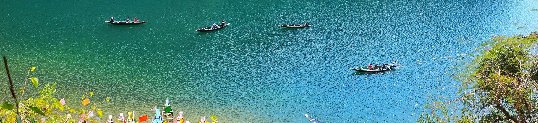
Ziro is a town and the administrative center of the Lower Subansiri district in Arunachal Pradesh.
It is on the Tentative List for the Apatani Cultural Landscape’s UNESCO World Heritage Site.
Ziro Valley, a captivating vacation spot in North East India, is concealed in the threatening
mountain range of Arunachal Pradesh. It draws tourists with its mesmerizing natural beauty, which is
filled with vast rice fields, endearing towns, and rolling green hills cloaked in dense coverings of
vibrant flora. It is famous for its paddy-cum-pisciculture farming. The area is renowned for its
terraced paddy fields, where the inhabitants practise a unique polyculture and water management
technique. During festive times, the community, which is predominantly inhabited by Apatani tribal
members, has a festive aspect. Numerous music enthusiasts, well-known national and international
bands, and folk performers now visit here for this “Ziro Music Festival” that started in 2012, which
is held in September, and depart from this lovely location with some priceless memories.
3 Namdapha National Park
Namdapha National Park is a 1,985-square-kilometer (766-square-mile) protected area in Arunachal
Pradesh, Northeast India. The national park is located in the Changlang district of the northeastern
state of Arunachal Pradesh, not far from the international border with Myanmar. In 1983, it became
publicly accessible. The Eastern Himalayas are a hotspot for biodiversity, with more than 1,000
floral and 1,400 animal species. The national park guards the world’s northernmost lowland evergreen
rainforests, which are located at It also supports vast dipterocarp forests, including the
ecoregion’s Mizoram, Manipur, and Kachin rainforests. It is the fourth-largest national park in
India. Namdapha was first established as a wildlife sanctuary in 1972, followed by a national park
designation in 1983, and then, as part of Project Tiger, a tiger reserve in the same year. Because
the river rises from the Dapha Bum glaciers, its name is a combination of two Singpho words: “nam”
(which implies water) and “dapha” (which denotes origin).
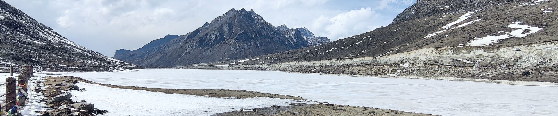
4 Sela Pass
The Sela Pass (also known as Se La, as La means Pass) is a high-altitude mountain pass in Arunachal
Pradesh that connects the districts of Tawang and West Kameng. It connects Dirang and Guwahati to
the Indian Buddhist town of Tawang at a height of 4170 m (13,700 ft). The National Highway 13
(formerly NH 229), which connects Tawang with the rest of India, travels across the pass. Sela Pass
does not experience extremely cold summers, but its winters can reach -10 degrees Celsius. The
Nuranang River, a tributary of the Tawang River, drains this lake, which frequently freezes over in
the winter.
Sela Pass is one of the most popular destinations in Arunachal Pradesh, and it is accessible by road
from Tawang through Route 13. There are many cabs available to get you here. Sela Lake, a well-liked
tourist spot, offers visitors a spectacular view of the mountains covered with snow. On your way to
the pass, you can also see some of the renowned silk routes.The ideal months to visit Sela Pass are
considered to be November to February.
5 Tezu
Tezu is a census town and the administrative center of the Lohit district in Arunachal Pradesh,
India. It is Arunachal Pradesh’s fifth-largest town and one of its most developed. The newest
airport in Tezu is Arunachal Pradesh’s first commercial airport. The first successful test flight
happened on September 22, 2017. The next-closest airports are in Guwahati (154 km) and Mohanbari
(Lokpriya Gopinath Bordoloi International Airport). Tezu has a road connection to the neighboring
state of Assam. Tezu is well known for its picturesque splendor, but adventurers can also go hiking,
river rafting, and trekking there. There are also amenities for hiking, river rafting, and fishing
on the Lohit. The walk from Tezu to Glow Lake takes one day.
The small hill hamlet is a well-known Hindu pilgrimage site and is thronged by many devotees who
come here to atone for their sins and purify their souls by bathing in the hallowed Parashuram Kund,
one of the region’s most well-known tourist attractions.
6 Roing
Roing is the district headquarters of the Lower Dibang Valley district in Arunachal Pradesh, India.
It is India’s final major municipality on the country’s north-eastern border.
The most popular destinations in Roing are: Wildlife Sanctuary at Mehao, Mehao Lake, Mayodia Pass,
Sally Lake, and Dihang Biosphere Reserve. Here’s how you can reach Roing by different modes of
transport By Air: Dibrugarh Airport, located 144 kilometres away, is the closest airport. From here,
you can either board an Arunachal Pradesh State Transport (APSTC) bus or hire a taxi.
By Rail: Tinsukia, which is 107 kilometres away, has the closest railway. To get to Roing, local
transportation is easily accessible from the station.
By Road: From all significant Assam and Arunachal Pradesh cities, Roing is easily accessible by
road. Using national highways 15 and 115, you can either hire a taxi or use the Arunachal Pradesh
State Transport (APSTC) bus service.
Roing and Tinsukia, two important Assamese cities, are connected by the huge Brahmaputra river,
which serves as the main route. Summertime flooding of the river necessitates a three-hour ferry
ride, which is quite an adventure.
7 Bomdila
Bomdila is the administrative center of West Kameng district in the Indian state of Arunachal
Pradesh. One of the 60 electoral districts in the state of Arunachal Pradesh is Bomdila. The
Eaglenest Wildlife Sanctuary is situated in the vicinity of Bomdila. The expansion of the
infrastructure in Bomdila has made tourism a significant source of income. There are many brand-new
inns and bed & breakfasts. It now serves as a stopping point for travelers heading to Tawang. The
majority of the foods served here is regional, however one can also order North Indian food. The
highest peaks in the state, Kangto and Gorichen Peaks, may be seen from the Bomdila Pass. The GRL
Buddhist Monastery, Buddha Park, and the statue of Guru Rinpoche should not be missed. One can visit
the new Bomdila helipad and take in the town’s entire panorama. Many people are drawn to the apple
orchards and orchid farms in the area. the old Lhagyala Monastery near Morshing Village, which is 70
kilometers away from Bomdila
8 Dirang
Dirang is a tiny town in the Arunachal Pradesh district of West Kameng. On the route to Tawang, it
is roughly 43 km from Bomdila. On the banks of the Kameng River, you may find Dirang (Known as Jia
Bharali in Assam). The altitude is quite low because it lies in the river valley (4900 ft). Most of
the year, the climate is not too chilly and is rather nice.
The valley’s scenery is captivating in and of itself. There is a bridge that crosses the Kameng
River, and on the other side, there is lovely paddy land. Another enjoyable evening activity is to
spend it shopping at the Dirang Market. Some attractions include –
Dzong Dirang
Due to its proximity to Bhutan, the local Dzong or fort has a noticeable Bhutanese influence. The
Dirang Dzong has existed for roughly 150 years.
Thermal Spring
The stairs to this hot spring may be found on the Tawang route about a kilometre ahead of the town.
9 Pasighat
Pasighat is the administrative center of the East Siang district of Arunachal Pradesh. Pasighat is
the oldest town in Arunachal and is located at 155 meters (509 feet) above mean sea level in the
eastern foothills of the Himalayas. In June 2017, the Indian government added Pasighat to the Smart
Cities Mission development plan. It serves as an Indian Air Force Advanced Landing Ground (ALG).
Some of the tourist attractions in Pasighat are –
Daying Ering Wildlife Sanctuary is one of the most well-known willdlife sanctuaries in Arunachal
Pradesh, India, and is a popular tourist destination in and near Pasighat.
Pangin: The distance between Pangin and Pasighat is around 60 km. It is located where the blue
waters of the Siyom River and the green waters of the Siang River meet.
Pasighat Buddhist Temple: The only Buddhist worship facility in Pasighat is the Pasighat Buddhist
Temple, which is situated on the side airstrip that faces the highway.
10 Itanagar
Itanagar is the capital and largest city of Arunachal Pradesh. It is home to the Arunachal Pradesh
Legislative Assembly, the state’s executive branch, and the permanent Naharlagun office of the
Guwahati High Court. The closest railroad station is Naharlagun, which is around 15 kilometers from
the city. From the train station, you can readily get bus and taxi services that will take you to
Itanagar.
11 Along
Aalo, originally Along, is the administrative centre and census town for the West Siang district of
Arunachal Pradesh. From Likabali, which lies on the border of Assam and Arunachal Pradesh, it is 137
kilometres (85 miles) away. It serves as an Indian Air Force Advanced Landing Ground (ALG).
The biggest festival, called Mopin, takes place from April 5 to 6. Every year, from 5 to 9 April,
during the busiest travel period, the Yomgo River Festival is held. This festival is held in order
to highlight the region’s rich cultural legacy and to promote tourism, indigenous culture, and
tradition.
The town is blessed with magnificent natural landscape which includes quiet valleys, lovely orange
gardens, and swaying millet and buckwheat farms. Two lovely rivers, Sipu and Yomgo, which meander
through the centre of this tiny village, add to its picturesque beauty and provide avid
photographers a terrific time.
You must plan to come here during the yearly Yomgo River Festival, which is held in January and
celebrates the region’s rich cultural heritage with exhibitions of local handicrafts, agricultural
products, and horticulture products.
This tiny village’s two charming rivers, Sipu and Yomgo, which meander through its centre, add to
its beautiful appeal and make for a great time for passionate photographers.
During the Yomgo River Festival, which takes place in January and celebrates the region’s rich
cultural heritage through exhibitions of local handicrafts, agricultural products, and horticultural
products is the ideal time to visit Aalo.
12 Nuranang Falls
Nuranang Falls (also known as Bong Bong Falls) is a 100-metre-high waterfall in Arunachal Pradesh’s
Tawang district. Nuranang Falls is also known as Jung/Jang Falls
It serves as both an Arunachal Pradesh tourist attractions and a source of electricity for the
community. The base is close to a small hydroelectric plant that produces energy.
Despite being one of the most magnificent waterfalls in the region of the country, few tourist are
aware of it. It is also known as the Jang Falls and is located about 2 kilometres from the village
of jang on the road that connects Tawang and Bomdila. The base is next to a small hydroelectric
plants that produces electricity for local usage.
The northern Sela Pass slopes are where the Nuranang River begins to flow . It empties into the
Tawang river immediately below the waterfalls.
How to Get There
buses are easily accessible from all parts of the city to Tawang.
Time: Daily from 8:00 AM until 6:00 PM
13 Bhalukpong
Bhalukpong is a tiny town in the West Kameng district of Arunachal Pradesh, India, located along the
southern foothills of the Himalayas. At 213 metres above sea level, the settlement is 100 kilometres
from Bomdila, 52 kilometres from Tezpur, and 5 kilometres from Tipi.
Tourist places in Bhalukpong
Pakhui Wildlife Sanctuary is situated in a picturesque place and spans an area of 862 sq. km. Pakhui
Wildlife Sanctuary is a visual delight thanks to its location in the Himalayan peaks and river
borders. The sanctuary is home to a wide variety of wild creatures, including the tiger, jungle cat,
Himalayan black bear, elephant, leopard, barking deer, flying squirrel, and many others.
Bhalukpong Fort, built in the 10th century but now in ruins, represents the history, culture, and
magnificence of the region. On the banks of the Bharali River, it was constructed by king Bhaluka.
Tipi is about 5 kilometers from Bhalukpong. Thanks to the Orchidarium located here, it is one of the
most well-known tourist destinations. Over 50000 different orchid species can be found in Tipi
Orchidarium.
14 Sangti
Sangti valley is situated about 14 kilometres from Dirang. It is encircled by the massive Eastern
Himalayan peaks, enjoys beautiful weather all year lobf with the possibility of light snowfall in
the winter, is covered in fruit orchards (kiwi fruits, apple, apricot, and orange), sprinkled with
pristine woods, and has meandering swift hill rivers. Black-necked cranes arrive in the area at the
end of November or the beginning of December, and they depart by the beginning of February (this
coincides with the lean period of the villages). Insects and grain left behind in the fields after
harvest are also eaten by cranes. The birds choose a marshy area in a farmer’s field as their
nesting locations.
The majority of the Morpa People that live here are Buddhists, along with some ancestors of the
animist religion. The animists still practise many sacrifice-based rituals. The majority of farmers
in the village cultivate maize and paddy, which is one of the vocations they engage in. In addition,
horticulture, the rearing the horses, pigs, sheep, cows, and goats, as well as chickens, is
practised.
15 Changlang
The Changlang District in Arunachal Pradesh’s southeast is home to a variety of wildlife and is
surrounded by beautiful hills. It is also the easternmost point in India and shares a border with
Myanmar (Burma). The World War II cemetery at Jairampur, the border village of Nampong with Myanmar,
and Pangsau Pass are all worthwhile tourist places. Bordumsa, where the Tais and Singpho have a
vibrant culture, is another interesting location. There are numerous vacation villas and attractive
spots in Namdapha National Park.
Tangsa, Singpho, and Tutsa are just a few of the fascinating and intriguing tribes who call
Changlang district home. There are also Nocte, Lisu (Yobin), Deori, and a few Adibasi tribes.
The social structures of the Tangsas and Singphos are democratic. They don’t have a system of kings.
The Panchayat, or Gaon Buras, arbitrates all village issues.
The district’s native population works primarily in agriculture and related professions.
Additionally, they raise domestic animals like chickens, pigs, goats, and cattle. Moh-Mol is a
Tangsas celebration that primarily celebrates agriculture and marks the completion of one
agricultural activity or the start of the next. Tribal people place the biggest importance on this
celebration because agriculture is the center of their way of life.
16 Bumla Pass
The Bum La Pass connects China’s Cona County in Tibet to India’s Tawang region in Arunachal Pradesh.
It is 37 km from the town of Tawang in India’s Tawang district. Currently, the pass acts as a hub
for trade between Tibet and Arunachal Pradesh. The border personnel meeting location for the
security forces of China and India is also there. Civilian tourists from India may visit with
authorization from the Indian Army. Only SUVs are recommended on th track, and only on clear days
without snowfall or rain because it is so dangerous. There are a few tourist places to visit at
Bumla Pass.
Sangestar Tso: There is a lake called Sangestar Tso (lake is called Tso in Tibetan), which was
formed by falling rocks, boulders, and trees after an earthquake.
Heap of Stones: Visitors can leave stones at this Heap of Stones as a token of appreciation for the
majestic Himalayas and the watchdogs of our northern frontiers. The friendship between China and
India is displayed here.
17 Mechuka
Mechukha or Menchukha is a town, assembly constituency, and subdivision located 6,000 feet (1,829 m)
above sea level in the Mechuka Valley of the Yargep Chu/ Siyom Riverr in the Shi Yomi district of
the Indian State of Arunachal Pradesh. In the Memba dialect, “Men” means Medicine, “Chu” means
Water -streams, rivers, etc., & “Kha” mean Show; Meaning “the land blessed with Mechuka valley was
formerly known as Pachakshiri before 1950s.
Due to its picturesque beauty, diverse tribes, soft hills, snow-capped mountains, and Siyom River,
Mechukha is steadily growing in popularity as a tourist destination in Arunachal Pradesh (locally
known as Yargyap Chu). A beautiful perspective of the valley is also provided by the Siyom River,
which runs through Mechukha.
A 400-year-old Buddhist Monastery, which is the go to spot for visitors, is situated on a
mountaintop in Mechukha’s westernmost region. Here you can also find a lot of old statues.
A renowned naturalist in North East India, found and reported a new huge flying squirrel from the
region.
18 Anini
Anini is the district headquarters of the Dibang Valley district in the Northeast Indian state of
Arunachal Pradesh. Additionally, Anini served as the unbroken Dibang Valley district’s
administrative centre. Its tiny size and lack of development are primarily due to its isolation.
However, it still has minimal air and road connections to the rest of India.
The majority of the inhabitants are from the Idu Mishmi tribe. For the majority of its commercial
requirements, the town completely depends on the closest large community, Roing, which is located in
the lower Dibang Valley District.
The Dibang Wildlife Sanctuary was established in 1992 and is located approximately north of Anini.
Due to the area’s high mountainous terrain, snowfall is frequent. The Arunachal Pradesh Department
of Environment and Forest is in charge. The lowest elevation is 1800 metres, and the highest point
is Kalaii Kala at 5000 metres. The woodland rest house and a hiking trail are two examples of
infrastructure you could come upon.
19 Daporijo
Daporijo is a municipal town in the Upper Subansiri district of Arunachal Pradesh, India’s
northeastern state.
Dapo and Rijo originally stood for “the valley” and “the protection” against an epidemic or evil
spirits, respectively. It houses the Upper Subansiri district’s administrative centre. Atop the
river Subansiri, this lovely hamlet is surrounded by limitless hills and is famous for the Daporijo
Bridge, one of the fastest-built bridges in BRO history, which was constructed in just 27 days in
April 2020.
The Trans-Arunachal Highway, which is part of the larger NH13, passes through Daporji. After heavy
construction equipment was heli-airlifted from Ziro, BRO built a strategic road in 2017 in Kurung
Kumey district between Huri (which is already connected to Koloriang) and Sarli. This road enables
connectivity between Koloriang-Huri-Sarli-Taliha-Daporijo by making it easier to build the remaining
Sarli-Taliha section.
20 Hayuliang Village
Hayuliang is a town and the administrative center of the Anjaw district in the north-eastern Indian
state of Arunachal Pradesh. It is situated close to the point where the Lohit and Delei rivers
merge.
The whole Delei River basin, including the Hayuliang Circle, Metengliang Circle, Guoliang Circle,
and Chaglagam Circle, is included in the Hayuliang subdivision, which is managed by an extra
divisional commissioner (ADC). The Hayuliang-Golang block and the Chaglagam block are the two
community development blocks that make up this area. Mishmis, who speak the Digaru Mishmi and Kaman
Mishmi languages, live in the Hayuliang.
It is located 308 kilometres from Itanagar, the capital of Arunachal Pradesh, 450 km from Imphal,
515 km from Dispur, and 543 km from Shillong.
Tinsukia in Assam is the closest railway station, located 235 kilometres away. The closest airport
is Tezu Airport, about 100 kilometres from Tezu district headquarters.
21 Pakhui Wildlife Sanctuary
Arunachal Pradesh’s East Kameng District is home to the Pakhui Wildlife Sanctuary, which is located
in the Eastern Himalayan foothills. It was formerly a part of the Khellong Forest Division before
receiving its current status in 1977.
It was designated a tiger reserve in 2002. The surroundings consist of lowland semi-evergreen,
evergreen, and Eastern Himalayan broadleaf woods. There are over 300 types of blooming plants, or
angiosperms, in the park’s lowland areas. There are also many orchids there. The Pakhui Tiger
Reserve is home to large cats including the tiger, leopard, and clouded leopard as well as canids
like the wild dog and Asiatic jackal (PTR). The Indian bison, elephant, barking deer, and barking
deer are the herbivores that are most frequently seen in this region.
The Pakke Tiger Reserve was first established as Pakhui Reserve Forest on July 1st, 1966, and was
later designated as a wildlife sanctuary on March 28th, 1977. It was renamed Pakhui Wildlife
Sanctuary in 2001, and on April 23, 2002, it became the 26th Tiger Reserve under Project Tiger of
the National Tiger Conservation Authority, becoming Pakhui Tiger Reserve.
22 Gorichen Peak
Gori Chen is an Eastern Himalayan glacier-fed mountain range. The third-highest peak in northeast
India is among the peaks.
It is one among the mountains in India that trekkers and expeditions frequently visit. Before the 19
Kumaon was deployed to Siachen in the 1980s, Gori Chen conducted training for the unit. The
Bailey-Morshead Expedition in 1913 and Bill Tilman’s expedition in 1939 are two older missions that
passed Gori Chen. The current Bailey Trail was inspired by the 1913 Bailey-Morshead investigation.
Experienced climbers can ascend Gorichen Peak or Sa-Nga Phu, whereas amateurs or beginners can hike
around the mountain’s perimeter. One of Tawang’s main tourist destinations, the summit is revered by
the Monpa tribe who live there and think it would protect them from all misfortunes. The majority of
visitors see Gorichen Peak while the route from Bomdila to Tawang.
The best things to do here are hiking and camping. In addition to this, Gorichen is approximately 25
kilometres from the renowned Nurunang Falls, so a trip there can also be planned.
The ideal time to travel here is during the warm months of April, May, and June and the month of
September following the monsoon season.
23 Madhuri Lake
One of the most well-known lakes in Tawang, Arunachal Pradesh, Madhuri Lake was originally known as
Shonga-tser Lake and was created by a flash flood following an earthquake in 1950. After the filming
of the Bollywood film Koyla, in which the stunning actress Madhuri Dixit starred, the lake was given
a new name. Beautifully verdant valleys and snow-capped mountains surround the lake. The best
approach to discover the lake’s gorgeous surroundings is by a leisurely walk.
24 Golden Pagoda, Namsai
A Buddhist temple of Burmese design, the Golden Pagoda of Namsai was inaugurated in 2010. Kongmu
Kham is another name for it in the Tai-Khamti language. It is situated in a 20 hectare (49 acre)
complex in the Namsai District of Arunachal Pradesh, India, 68 kilometres (42 miles) away from the
nearby train station in Tinsukia, Assam.
At the Golden Pagoda, the Kathina festival is the biggest event. Thai Buddhist monks took part in
the event for 2016 on November 13 as well. The monks presented the Pro Bpor Ror, an image of Buddha
that had previously been held in Wat Bowonniwet Vihara, as a gift on behalf of King Bhumibol
Adulyadej of Thailand.
The Golden Pagoda also received a Kalpatru (Money Tree) from the Thai monks. On the final day of the
festival, the Loi-Krathong ceremony, which is symbolised by the release of floating lamps into the
Mungchalinda Buddha pond, is also held.
A library, a monastery, and a centre for Tai Khampti-singpho tribes cultural research are also
located in the region. A tourist destination nearby offers lodging in the form of private villas and
dorm rooms.
25 Aalo
Aalo, formerly Along, is the administrative and census town for the West Siang district of Arunachal
Pradesh, India. It is 137 kilometres (85 miles) from Likabali, a border town between Assam and
Arunachal Pradesh. The Indian Air Force uses it as an advanced landing ground (ALG).
From April 5 to 6, the largest festival, called Mopin, takes place. The Yomgo River Festival is
conducted every year from April 5 to April 9, which is the biggest travel time. This festival is
held to raise awareness of the area’s rich cultural heritage and to advance travel, traditional
cultures, and indigenous cultures.
The village has a beautiful natural setting that includes serene valleys, exquisite orange orchards,
and swaying millet and buckwheat farms.
Aalo’s closest airport is in Pasighat. It has flight connections to places like Guwahati, Dibrugarh,
and Tezpur, among others. From Pasighat to Aalo, one may take a bus or a taxi.
The closest railroad station is in Murkongselek, while Aalo has none. The survey for a new broad
gauge railroad line between Aalo and Silapathar has already been finished and sent to the railway
board.
26 Tawang Monastery
The Tawang Monastery, which is located in Tawang City and Tawang District in the Indian state of
Arunachal Pradesh, is the largest monastery in the country. In the northwest of Arunachal Pradesh,
near to the border with China and Bhutan, it is situated in the Tawang Chu valley, close to the
little town of the same name.
The Tibetan name for Tawang Monastery is Gaden Namgyal Lhatse, which means “the divine paradise of
flawless victory.” In accordance with Ngawang Lobsang Gyatso, the 5th Dalai Lama’s intentions, Merak
Lama Lodre Gyatso established it in 1680–1681 It is associated with the Drepung Monastery in Lhasa,
which survived the british rule, and is a part of the Vajrayana Buddhist Gelug school.
Three storeys make up the monastery. It is encircled by a 925-foot (282-meter) long compound wall.
The complex consists of 65 residential buildings. Predominantly Kangyur and Tengyur, rare ancient
manuscripts may be found in the monastery’s library.
In 1680-1681, Merek Lama Lodre Gyamsto founded the monastery at the 5th Dalai Lama’s request.
27 Nemisai
Namsai is the administrative centre of the Namsai district in the India state of Arunachal
Pradesh.The opening of the long-awaited bridge over the Nao-Dihing river in March 2002 gave the
township, which is close to the river, a significant boost. The 660.37 m long bridge has moved up to
second place in Arunachal Pradesh following the opening of the Parasuram Bridge, which is located 85
km to the north of Namsai. Below are the two must visit places when you travel to Namsai!
Golden Pagoda
Tengapani’s exquisite Kongmu Kham is located on the banks of the Teang River. The enormous golden
pagoda, built in the Thai/Burmese style, is majestic and exudes peace as it stands in the center of
a lovely planted garden surrounded by lush flora.
Buddha Vihara in Chongkham
The historic town of Chongkham is where you’ll find the Buddha Vihara. In front of the Buddha statue
that encircles the inner core of the vihara, this location provides a haven for the mind and is
perfect for meditation.
28 Khonsa
One of the first five districts of the state of Arunachal Pradesh, Khonsa was established during the
British era. It is the district headquarters of Tirap in the Indian state of Arunachal Pradesh.
Khonsa shares borders with Assam in the south and Myanmar in the east. Khonsa is an idyllic
destination in the eyes of tourists, who may take in the surrounding views of dense forests bordered
by hills. The magnificent Himalayan peaks around this village in Tirap Valley. The area is
breathtakingly beautiful, and the streams, deep gorges, dense forests, and snow-covered hills just
contribute to that. Wild animals such as tigers, leopards, jackals, wild boars, bears, barking deer,
red pandas, musk deer, mithun, and several types of rodents can be found in the forests surrounding
Khonsa.
It is the ideal location for anyone who likes adventure, offering thrilling treks through thick
forests. The woodlands, which are home to various rare species of orchids, delight in April by
blooming with these exotic and uncommon flowers. A great characteristic of this area is the tribal
culture, which includes their festivals, fairs, and flawless artworks created with steadfast
devotion.